About Us
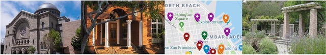
Map Of Jewish San Francisco
Reflecting Sinai's longstanding commitment to the Bay Area Jewish community, we have created an interactive map to highlight the many ways Bay Area Jews have shaped the region. From architects and businesspeople to professionals and philanthropists, Jews have made tremendous contributions to the social, political, and cultural landscapes of the Greater Bay Area.
We’ve prepared a map showing many sights in San Francisco and surrounding areas that relate to Jewish life, as well as five maps of walking tours that highlight different parts of the region, and one driving tour. These tours can also be broken up into shorter routes.
While most sights on these maps still exist, red pins on these maps mark the locations of ones that no longer exist.
Map of Jewish San Francisco
To search the map for keywords, click the expand button in the top right. Then, select the magnifying glass at the top of the sidebar.
This is the complete map, showing sights related to residences, businesses, Jewish institutions, and places named for Jews from San Francisco.
Walking Tour 1: The Financial District to the Embarcadero
This tour starts in the Financial District, explores sights on Nob Hill, goes to Coit Tower, and ends at the Exploratorium on the Embarcadero.
Other highlights on this tour include the Sentinel Building and the place where Allen Ginsburg wrote “Howl.”
Click here for step-by-step directions and to learn about the sights included on this tour.
Walking Tour 2: Civic Center to Presidio Heights
This tour starts with several cultural venues in the Civic Center area and proceeds through Hayes Valley and the Fillmore District (once a thriving Jewish neighborhood) before visiting the Mount
Zion Hospital area and homes in Presidio Heights.
Click here
for step-by-step directions and to learn about the sights included on this tour.
Walking Tour 3: South of Market Street to the Financial District
This tour starts in SOMA, passing the Contemporary Jewish Museum and buildings that once housed department stores started by Jews and ending at the Crown-Zellerbach Building, one of the city’s first international style buildings.
Click here
for step-by-step directions and to learn about the sights included on this tour.
Walking Tour 4: Presidio Terrace to Polk Gulch
This tour starts in Presidio Terrace, where many prominent Jewish families once lived, and passes by two of San Francisco’s oldest synagogues.
Click here
for step-by-step directions and to learn about the sights included on this tour.
Walking Tour 5: Berkeley
This tour starts near Shattuck Avenue and moves through the campus of UC Berkeley and along Telegraph Avenue before concluding downtown.
Click here
for step-by-step directions and to learn about the sights included on this tour.
Driving Tour: Pioneer Jewish Cemeteries
This driving tour highlights the Gold Rush-era Jewish cemeteries of the California Mother Lode.
Click here
for step-by-step directions and to learn about the sights included on this tour.
This map was created by Jacob Isaacs as part of the Kohn Summer Intern Program of JVS.
Sinai thanks Marc Dollinger, Victoria Fisch, Jeremy Frankel, John Rothmann, and the Jewish Community Library for their help on this project.
To suggest additions or corrections, please contact info@sinaichapel.org.